Historical Research as Tool in the Residual Unexploded Bomb Risk Assessment: Case Study Sarajevo
by Sead Vrana
Fifteen unexploded aircraft bombs are found in Sarajevo area since 2013. Ten of those are found inside the city limits, eight of them were 1000 lbs. (454 kg) bombs and seven are under the already processed or built up surfaces. One is found in the foundations of the house, one under the street, one under the parking lot, and four in the factory building foundations, all at depths from 1 to 5.5 meters. Four bombs were found over a 6-day period in September 2019. All bombs found within the city limits were less than 150 meters away from the residential buildings and five of those were less than 50 meters away. Fourteen bombs, all those found in the city area among them, originate from the World War Two period, 10 were British, three French, one US and one German.
Even though the majority of the bombs were found in the populated urban area where uncontrolled detonation may cause severe consequences, until now no formal risk analysis has been undertaken. Following International Mine Action Standards and GICHD MORE guidelines risk exists on the location where contamination is present during the activities which may interact with the contamination, so for the understanding of the risk it was necessary to analyze all available pieces of information related to the characteristics and distribution of the contamination. Practically that meant search for the available historical sources and testimonies, their verification and the analysis of the data collected from those sources.
Sources and data collecting
As 14 out of 15 bombs originate from the World War Two, focus of the research is put on that historical period. In order to identify data sources that contain satisfying level of information, initial research, reduced to the examination of the previous studies on the air war from 1941 to 1945, is done. Works of Shores and Cull, Richard G. Davis, Kevin A. Mahoney, Allan Grainfeld were extraordinarily useful for this part of work, since above mentioned authors identified units engaged in bombardment and in few cases dates of the attacks and gross tonnage dropped.
Based on the results of the initial research detailed research is undertaken in the published and unpublished archives, in order to find bombing related documents with more detailed data. Unpublished archive materials were found in The National Archives of UK and in the Air Force Historical Research Agency (AFHRA). From these sources we obtained following documents: operational orders, summary and narrative reports, operational records and aerial photographs related to the bombardment groups’ and squadrons’ missions.
Published archive materials were found on the historical web sites of the bombardment groups that were part of the USAAF 12th and 15th Air Force. These sources provided facsimiles and transcripts of the operational orders, narrative reports and vertical photographs of the bombing of the targets in Sarajevo. Problem which aroused during the analysis of these documents was their verification. To avoid working with the unverified documents all data were exclusively collected from the official web sites and all collected documents were crosschecked by comparing to the verified data. If document was not verified in this manner, it was not used. Primary sources in the work were authentic archived documents while documents obtained from the web were used only in cases in which no other source was found. Data found in the documents obtained from mentioned sources were used in the analysis of the contamination characteristics; types and quantities of the bombs dropped and fuzing setups. These sources have also contributed data about the attacked targets; ie. distribution of the contamination, but many more details on this subject were found in the documents produced by the local military and civilian authorities in Sarajevo. Military authorities’ documents are published in the Corpus of the Documents and Data from The Liberation War by Military History Institute of the Yugoslav People’s Army in Belgrade, while civilian authorities’ documents are kept in the inventory of The Historical Archives of Sarajevo.
Data interpretation
Through the analysis of the information available in different sources, 18 bombing missions on targets within Sarajevo city limits, and 51 fighter/fighter-bomber attacks in the vicinity of Sarajevo are identified. Due to the fact that bomber attacks delivered approximately 20 times more bombs across a much narrower area, this analysis is focused on the bombings within the city limits. In the documents obtained from The National Archives and AFHRA, data related to the 11 attacks were collected while the documents obtained from the web provided data for the 4 attacks. No original documents related to the 3 German bombings were found. Also in the local military and civilian authorities’ archives, records of all bombings, except the German ones, were found. So German attacks were researched indirectly by coopting data from the previous studies and recorded testimonies so this part of the work is not complete and results are not final.
Air force unit’s records contain following sets of related data; target, sighting method, formation and bearing of attack, amount and types of bombs, fuzing setups and delay, target area coverage and bombing efficiency. Local authorities’ records contain data on; estimated number of bombs dropped, stricken locations, unexploded bombs found after the attacks, damage and victims. While analyzing these data it was noted that data provided by the different sources related to the same aspect of the same bombing might be significantly different. To avoid equivocality and confusion in the analysis, only data that could be reliably identified by the author of the record or the document, and which were relevant for the outcome, were used. From air force unit’s records data related to the types and quantities of bombs, fuzing setups and target area coverage are used, while from local authorities’ records are used data on damage, stricken locations and unexploded bombs. Also, for the specific bombings, number of the remaining craters, if available, was compared to the number of dropped bombs. Level of data in collected records enabled successful establishing of the contamination distribution ie. identifying locations where presence of the unexploded bombs is plausible. For several locations technical characteristics of the possible contamination are identified while for some, the only characteristic determined is the origin of the bombs with no data on type and quantity.
Results
By analyzing the data two main targets in Sarajevo are identified, Alipašin Most marshaling yards or Sarajevo West m/y and Railway workshops and junctions or Sarajevo East m/y. 90% of bombs dropped on Sarajevo targeted these areas. Alipašin Most was an exclusive target in 6 and shared in 3 allied attacks, while Railway workshops were exclusive target in 3 and shared in 3 attacks. As Alipašin Most is the area of interest in future construction works, focus is put on this area. In the attacks that aimed this area total of 3237 bombs form 250lbs to 4000lbs were dropped with the average accuracy of the 37% (percent of bombs which fell within 300-meter radius around the aiming point). As nearly 2/3 of the dropped bombs ended up elsewhere the challenge was to identify areas hit by bombs which missed the target. Aerial photos of the bombings provided fair portion of the needed data and in cases where no photos were available local authorities reports were used. Specific criteria were applied for the evaluation of this data, so evaluation is made upon the frequency and quality of mentioning of each specific single location in the narrative reports. Total of nine stricken areas are identified, including Sarajevo downtown, and narrower spots where bombs hit are isolated within their boundaries. As no data on bombs disposed from 1945 to 1992 are found, assessment is established by cross-referencing recent findings and data obtained from the historical sources.
Out of 10 bombs found within Sarajevo city limits during last 15 years, 2 were found within 500 meters from the railway switch and the bridge at Dolac Malta, one within 500 meters from old train station at Pofalići and 7 within 700 meters from Alipašin most marshaling yards (four in the target area). Comparing this number with the historical analysis’ findings, localities of Alipašin most, Buljakov potok, Alipašino polje and Švrakino selo in municipality of Novi Grad have a high risk from unearthing of an unexploded bomb at depth of 3 to 6 meters. Localities of Dolac Malta, Hrasno, Čengić vila, Otoka, Pofalići and
Buća Potok in municipality of Novo Sarajevo have an intermediate risk of finding of an unexploded bomb. As bombings struck every part of the city, findings are also possible in the areas within municipalities of Centar and Stari Grad but risk of finding them in these areas is low.
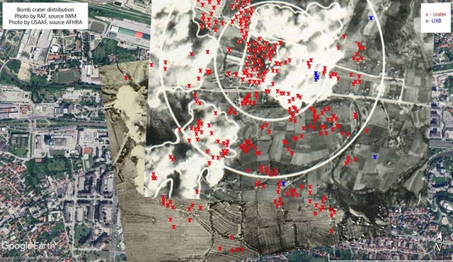
Alipašin Most, as area of specific interest, where two major civil engineering projects are planned in near future, is subjected to mathematical calculation of the probable unexploded bomb according to the distribution and density of the craters. For this purpose is used methodology explained in paper
„Calculation Of Per Parcel Probability For Dud Bombs In Germany“ by Seyed Mohammad Tavakkoli Saboura, Jürgen Agariusb and Javad Sadidia published in “The International Archives of the Photogrammetry, Remote Sensing and Spatial Information Sciences”, Volume XL-2/W3 in 2014. For the purpose of this part of the analysis density and distribution of the craters is determined from the available aerial and the bomb plot photos aligned with the city plan in the geographical information system (see image). Five layers/photos from the different attacks were used in the process. After the craters and known bomb impact spots were plotted and spatially identified, local 20x20 meter grid is established over the area and the probability is calculated for each of the grid squares which fit within the determined locations of interest (location for the congress center building, the route of the city expressway). This analytical method is tested by calculating probability of the unexploded bomb presence on the locations where bombs are previously found with the accuracy of 76%. Upon obtained data possible presence of the two unexploded bombs is calculated on the location where congress center building is planned. Calculations for the expressway are not completed at the moment of the writing of this paper.
Technical characteristics of the contamination obtained from the historical sources match with the field findings. Bombs used for the bombing of the targets in Sarajevo range from 50 to 250kg in German attacks and from 250 to 4000lbs plus flares and target markers in allied attacks. Fuzes used are impact fuzes with .01 to .25sec delay. In two occasions long delay fuzes set to 6-72hrs were used on total of 109 bombs. Gross tonnage dropped is 1100 tons in all attacks.
Conclusion
As a method historical research is highly dependable on the quality of the entry data for each specific location, so consistency of the research, amount and quality of the pieces of information directly affect the outcome. Insufficient entry data may give incomplete result while inadequate processing might lead to even completely wrong conclusions. That might cause in taking the incomplete results for final, so all results must be constantly reevaluated, especially in light of every new related piece of information obtained.
Historical research is a strong asset in the risk prediction and assessment especially as all the work can be done during the periods with no field activity while it provides ‘field related’ result. As a tool it is primarily applied in the unexploded aerial bombs risk management, but it’s elements can be used in other similar residual UXO risk analysis. Applied methodology can be fairly used for the risk assessment throughout South-East European cities which sustained bombardment of the similar intensity as Sarajevo. This research provides an input for the upgrade of the present practices in the unexploded bomb management. The most prominent are improvement of the training curriculums for specific rendering safe and disposal procedures, more efficient planning of the ground search and support to the excavations, population evacuation and area isolation protocols, damage mitigation and control processes and implementation of the risk education in the endangered population like construction workers and public safety officers.
Image: Crater distribution in Alipašin most area over the aerial photos aligned with the city plan.